
Chase Log: Bonham-Honey Grove, TX Tornado – 24 April 2020
The Setup
There’s a lot to dissect from yesterday’s event. From early morning observations and model guidance, it appeared that a lot of the necessary ingredients were in place for significant tornadoes to develop later in the afternoon and evening. A favorable surface low was positioned over the region, however moisture return was the main outstanding variable and guided much of my decision-making from the morning throughout the afternoon.
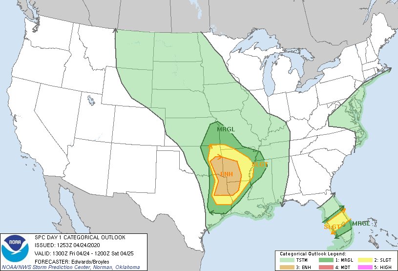
The morning SPC outlook on 24 April 2020.
The morning outlook from the SPC centered the highest probability of tornadoes along the greater Red River Valley region in an area from east of Durant, OK extending into western AR and LA. Model runs from the HRRR, NAM NEST, and RAP were mostly consistent that once storms started developing, the greatest tornado potential existed along the Red River corridor and would taper out in southwest Arkansas or northwest Louisiana, the oft described Ark-La-Tex region that is infamous for the increasing density of tree cover the further east you travel.
Indeed terrain is the highest ranking factor when I make a go/no-go decision to chase. Northwest Arkansas yields beautiful landscapes any day of the week except for chase days, so I’ve come to respect the hills and forests that predominate in eastern Oklahoma at the heart of yesterday’s risk area. So my concern was well founded that storms firing too far north of the Red River and tracking across the southern Ouachita Mountains would make for a less-than-desirable experience. I made the decision prior to leaving that if the only storms that fired-off were destined for that trajectory then I would follow them and make use of one of my drones to capture photos and video, otherwise I would stick with whatever I could find along the river.
I left home shortly before noon after settling on the Antlers to Hugo, OK area as an initial target. There are about 5 river crossings from Oklahoma into Texas along a nearly 100 mile stretch east of Durant, so I would need to make a decision prior to starting my chase as to which side of the river I would be stuck on. I spent nearly two hours waiting in Hugo and watching the evolving surface environment. Around 5 in the evening, a cumulus deck started developing near Durant as a nose of high CAPE developed across the river from Texas into Oklahoma. Moisture return was still the outstanding variable, but it didn’t take long for 60-degree dew points to follow in kind.
I could see cumulonimbus towers firing off to my west, but delays in getting timely satellite imagery and limited low-beam radar coverage meant I had to eyeball their location from my vantage point. I took a short drive down Highway 271 towards Paris, TX in an effort to triangulate their position and made the fateful choice that the southernmost cell (my preferred target) was just north of the river. I double-backed and began driving west along Highway 70 towards Durant, realizing about a quarter of the way there that the southern cell was just on the south side of the river, but I had sealed my fate by that point.
Bokchito, OK Intercept
I consider myself an opportunistic storm chaser. My main objective is to take photos and still frames for a growing inventory of time lapse sequences that I’ll stitch together for a short film in the future, so I love good structure shots. There were two cells that I was watching as I drove west on Highway 70 – a stronger cell over Durant and the southern cell that was in a slightly more favorable environment without any other development downwind of it that could pollute its environment. Both cells had elevated cloud bases and few visual cues of rotation, but I was about to discover how quickly that could change.
As I approached the town of Bokchito and the encroaching rain shaft of the Durant cell, the storm went severe-warned and began shifting its trajectory towards the southeast. I took a county road south of town until I felt I was sufficiently out of the storm’s path that I could find a clear vantage point to set up a time lapse sequence. I made quick work of setting up my primary camera (a Canon 6D Mark II) and framing the storm so that it would track across the field of view for as long as possible. In the time it took for me to set up my camera, the storm went from flat cloud base to rapidly evolving wall cloud – all in a matter of what seemed like a few minutes. Unfortunately, I had to cut the initial sequence short after realizing that I left the auto-focus on (a big no-no in time lapsing and the easiest thing for me to overlook as I’m getting set up). But I salvaged the shot and managed to get over 10 minutes of prime footage and a little less than 5 minutes on a secondary time lapse as the storm cycled into a more outflow-dominant mode.
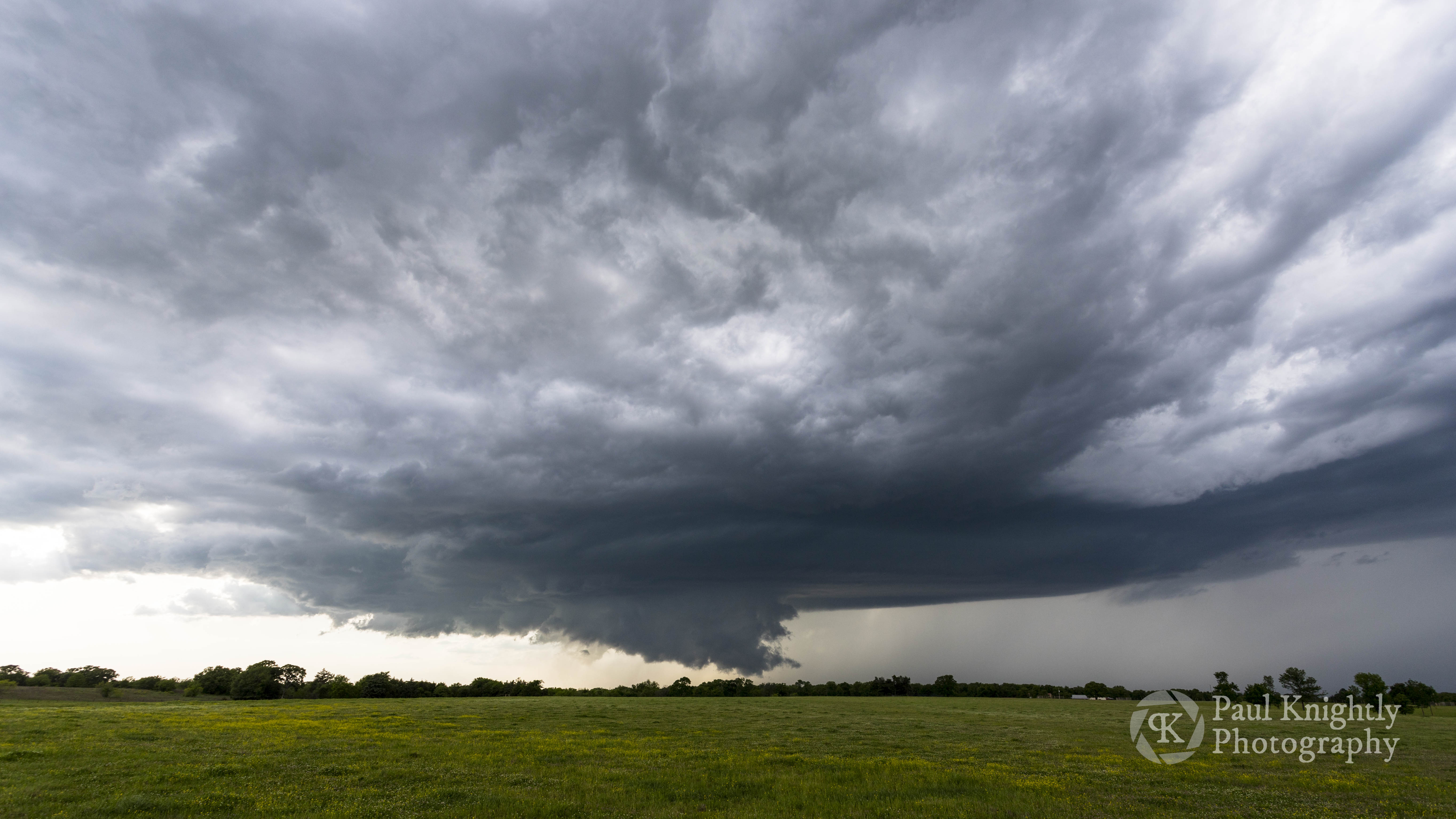
A still frame from a time lapse sequence of the Bokchito, OK supercell.
Bonham-Honey Grove Tornado
While I was time lapsing, I used my secondary camera (a Canon EOS Rebel T3i) with a telephoto lens to get some close-up shots since my prime camera was capturing the scene at a wide angle. If there’s a lot of cloud-to-ground lightning, I’ll set up my second camera with a lightning trigger to try and get lightning shots, but CG bolts were hard to come by yesterday, so I was shooting free-hand with the long glass.
I was keeping an occasional eye on the southern cell that was now at my back and moving east-southeast, but the structure was limited and the large wall cloud on the Bokchito cell had my full attention. Another storm chaser had parked behind me and was time lapsing the scene and we bantered a little bit (from a socially distanced 30 feet) but mostly kept to ourselves. Suddenly he shouted out “Hey man! Tornado! Behind you!”
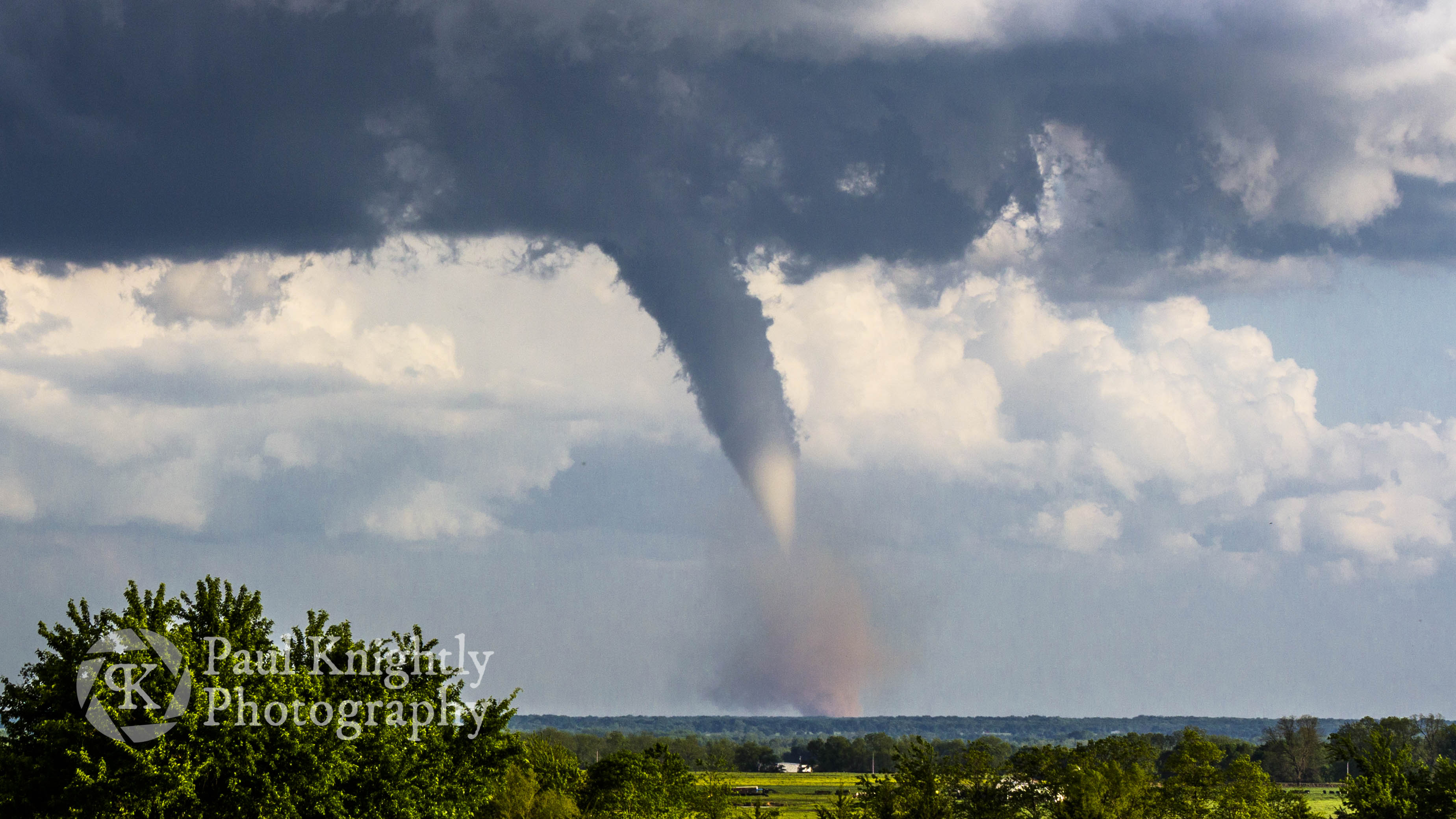
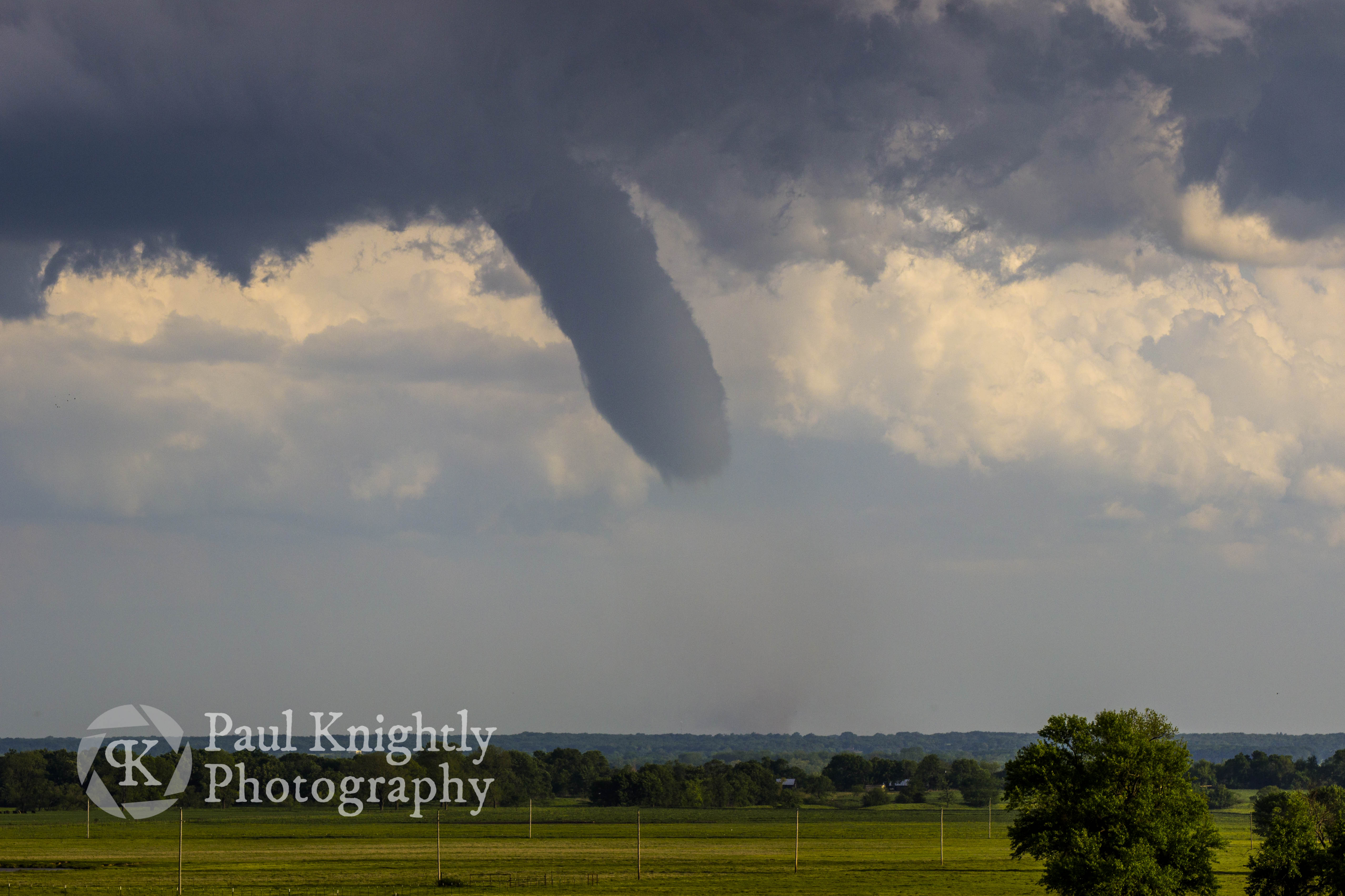
Tornado touches down east of Bonham, TX pulling a column of red dirt into the funnel.
I turned around in time to see the first phase of the Bonham tornado lifting and then re-condensing as it started picking up dust to our south. I trained my second camera to the south and began getting photos as the tornado became more well-defined. Playing double-duty, I checked the field of view in my time lapse and decided to quit the time lapse since the cell had become outflow dominant for the moment and was starting to exit the FOV.
There was a river crossing to my southwest, but I chose to stay north of the river and that I would lose valuable time if I tried to reposition. I knew I would lose the storm sooner as a result, but that was the price I was willing to pay in an effort to get better photos of the ongoing tornado. I continued east until I found a series of clearings from which I could get a clean view. My biggest chasing regret was missing the 2013 Rozel, KS tornado after bailing to a southern cell that “looked” more favorable. I’ve spent the past 7 years hoping for a tornado that was even just half as photogenic, and Bonham-Honey Grove delivered.
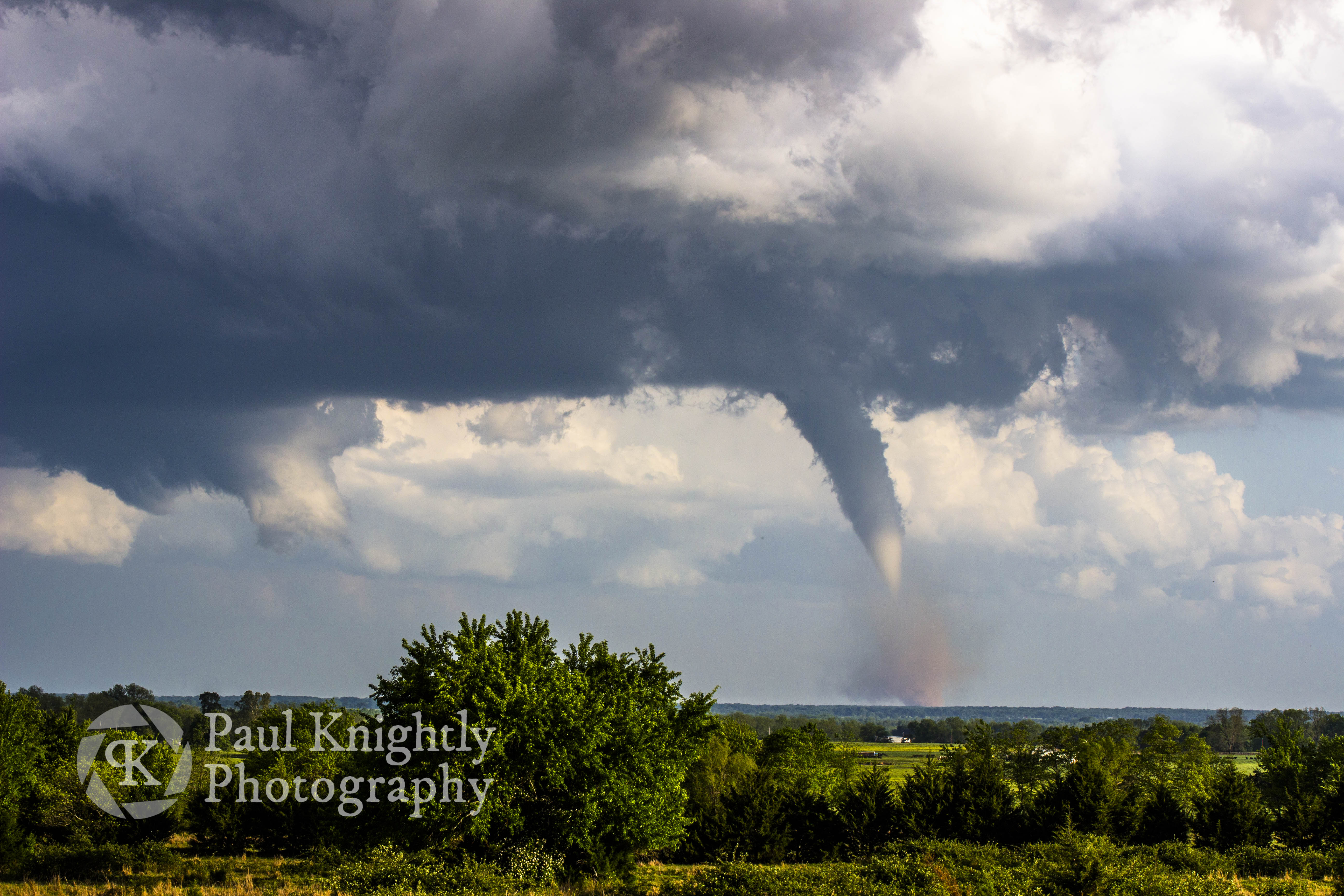
The tornado went through several phases of not having a fully condensed funnel, in this case sporting an elephant trunk for a period of time.
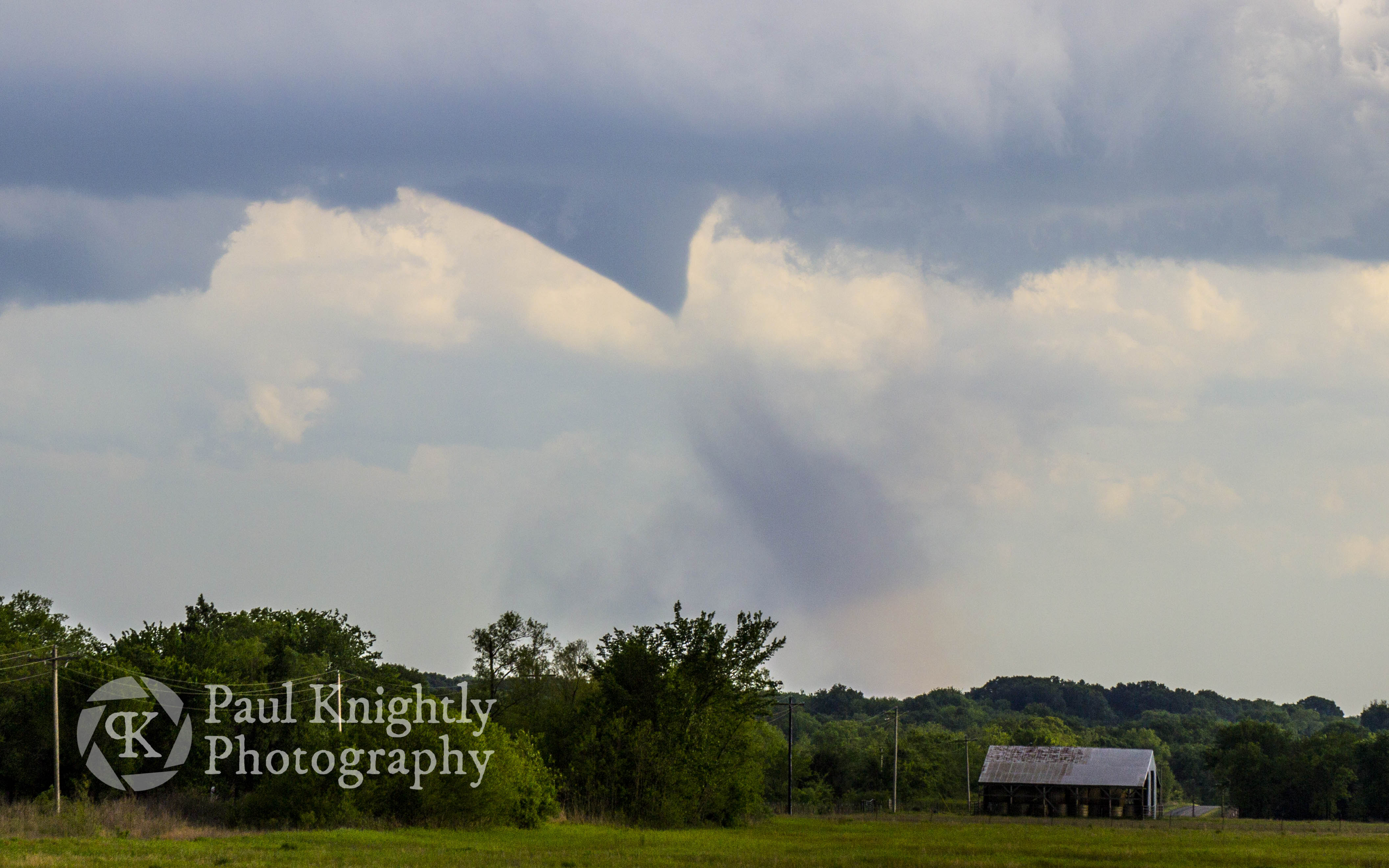
As the tornado gained momentum, another wall cloud developed to the east and for a brief moment it seemed like the storm would try to generate a second, simultaneous tornado.
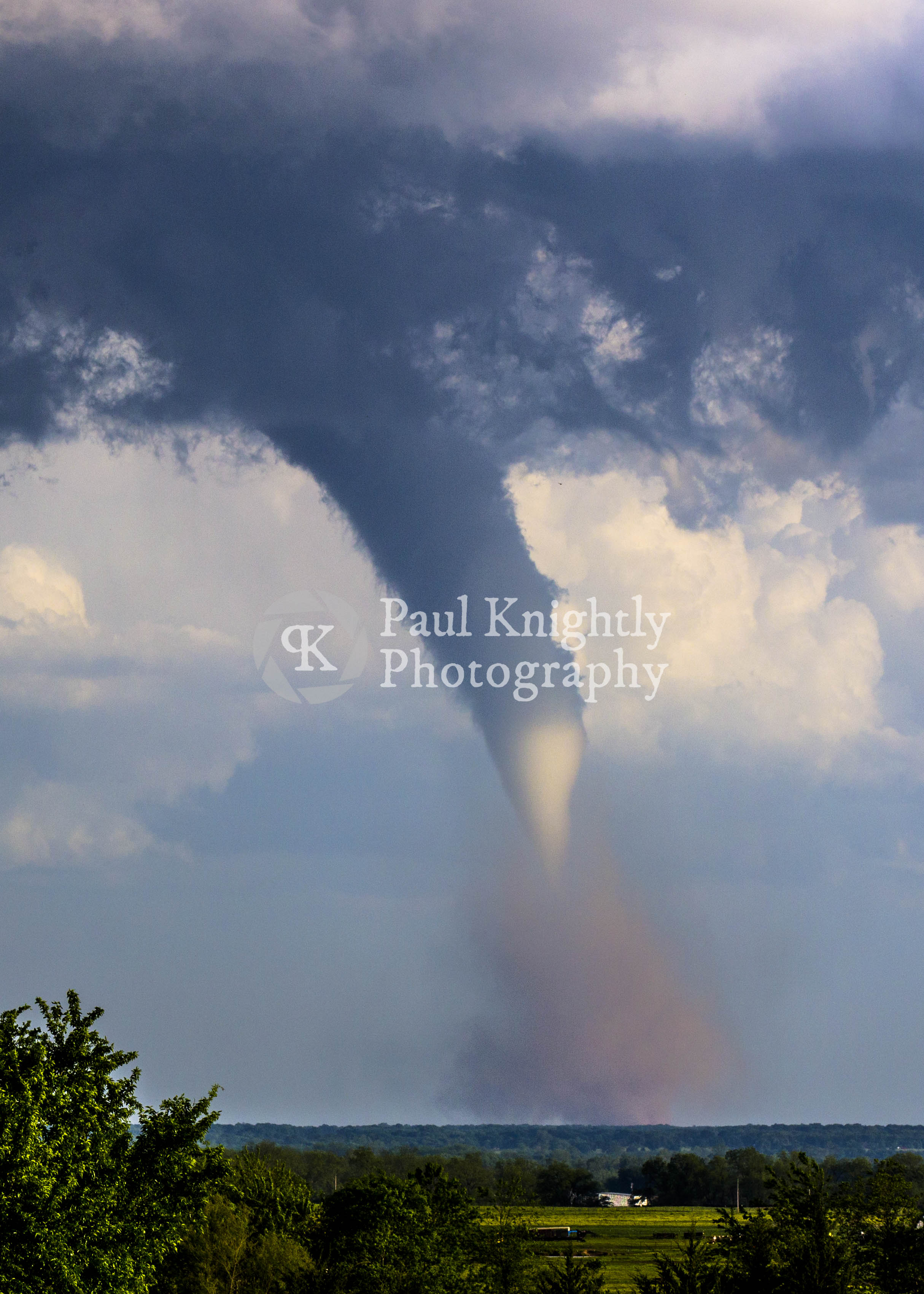
The Bonham-Honey Grove, TX tornado in full drill bit mode.
After the tornado roped out, I continued on the Bokchito cell that was now tracking to south of Bennington (Oklahoma). The storm had reorganized and had a well-defined wall cloud and was ripping a strong rear-flank downdraft (RFD) in its wake. I drove through the RFD until I couldn’t go any further east and started north towards Bennington and captured my second favorite view of the day. A rainbow and the wall cloud amongst the RFD!
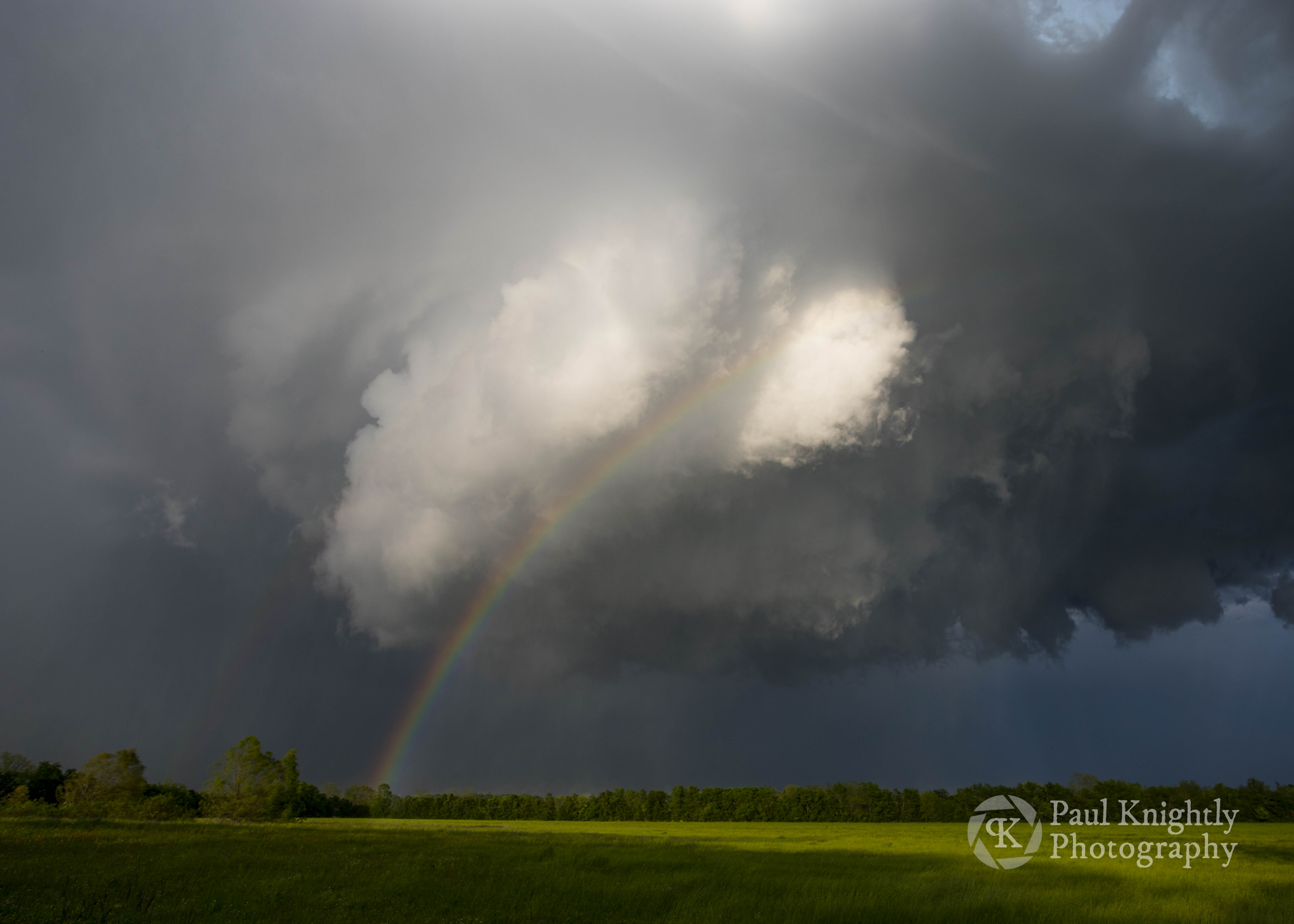
Bennington X.0 – Rainbow in the RFD.
The storm crossed the river shortly after that, thus ending my chase day. I hoped to get some lightning on the way home but CG bolts were as limited as the views, so I jammed to my red dirt country playlist as I replayed my first Red River tornado through my mind.